Showing posts with label Icklingham. Show all posts

Saturday, September 22, 2007

Icklingham and Cavenham Heath Suffolk

Share
10am 10.7 miles in 1 hr 30 mins
Week to date mileage 33 miles
Month to date mileage 123
Average weekly rate 30.7 miles
Average monthly rate 133
Year to date 1161
Lifetime 10754

With the Felixstowe Half Marathon next Sunday I decided to get in a long run today and I drove out to Icklingham which is named after the enclosure of Yccels People. Icklingham as a settlement is on the line of the ancient Icknield Way. It is an area of heathland and two parish churches of All Saints and St James.

I parked up near some bungalows opposite St James and headed off past the old school and along West Road. When the houses cease you are onto open plains and have options. You can either take the Icknield Way and venture into Cavenham Heath which has a wild heathland tranquility or you can do what I did which was to take the first footpath I came across. This took me in a diagonal line across a heath but emerged on to the busy Mildenhall Road.

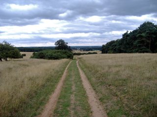
So rather than follow this I noticed an unmarked pathway which a jeep or some other vehicle has made over Icklingham Plains. This is an area of conservation and I think it is ok to follow this but there were no real markers for my off road run in the soft sandy heathlands.
This was an absolutely beautiful run, if you ignored the distant sound of traffic from the Mildenhall Road then I had the world to myself in splendid isolation apart from a million rabbits. This is undoubtedly rabbit heaven, a rabbit kingdom.
You had to watch your fit as every tread could be into a rabbit hole. Every so often rabbits tore left right and centre and I had the feeling I was running across a giant rabbit warren the ground underneath my fit just being a large honeycomb structure of tunnels.

A long row of telegraph poles broke up the endless heathland, apart from this there were odd rows of beautiful scots pines.
The trackway made by the jeep wheels became more indistinct but I continued on in the hope of reaching a landmark of some sorts. This was reached when I arrived at a small woodland area. The ground here was ankle deep in grassy mounds and I was unable to get a good footing. I could have carried on but my feet were now wet and there was a real chance of getting lost with no directions. Then came one of those great moments when I stumbled upon a deer and the animal stood stock still staring at me giving me a chance to get a rapid photo but not a very good close up before it bolted.

I returned back to Icklingham and then decided to follow the path of the ancient Icknield Way the oldest road in the country. This took me into Cavenham Heath and after a runaround the heather filled heathlands I returned and ran the length of the village of Icklingham before finishing an enjoyable run.
Thursday, August 10, 2006

Icklingham Suffolk

Share


9.30am 11 miles in 1 hr 30 mins 01 seconds

Week to date mileage 17

Month to date mileage 47

Average weekly rate 31.7

Average Monthly rate 138

Year to Date 1005

Life time 8783

I drove out to the West Stow Country Park and parked near the reconstructed Anglo Saxon houses,swings and visitors centre. I set of for my run out past the Wideham Cottages and along the road leading to the Ramparts Fields. Before reaching here I took a right turning leading me on to the Icknield Way.

The Icknield Way always brings an air of excitement to step on to an ancient pathway and to think of the many generations of travelers predating the Roman occupation who would have walked here before me.

The Icknield Way is unique among long distance tracks because it can claim to be "the oldest road in Britain". Extending from Ivinghoe Beacon in Buckinghamshire to Knettishall Heath in Norfolk. The path runs for a 103 miles and dates back at least as far as the late iron age c100bc but may be older dating to the Neolithic period c4500 bc.

Instead of following the Icknield Way through the Kings Forest I took a left to follow the Icknield Way and Lark Valley path to Icklingham.

At Icklingham you can visit 2 churches and 2 pubs. All Saints Church is being restored and is a little bit out of the centre of the village so St James is the focal point for locals.

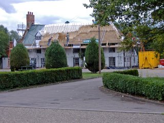
The Red Lion is the larger of the 2pubs and sits on the River Lark. It is currently being re thatched. The Plough Inn is a smaller flint building which probably gets by passed by visitors who head for the bigger gardens at the Red Lion.

I ran through the centre of Icklingham and picked up a footpath near Church Farm which took me out into the heart of Breckland said to be the desert of England because of its sandy soils and the unique character of the Breckland. This is the home of both rabbit and flint by the millions. Some people would say there is nothing there but that is to miss the beauty of the place its solitude unbroken for me apart from the occasional USAF plane taking of from Mildenhall and Lakenheath.

Sunday, January 15, 2006

West Stow Suffolk

Share
9.45am 13 miles in 1 hour 46 minutes

Week to Date mileage 31

Month to date mileage 75

Average Monthly rate 152

Weather: Dry cool

I found my camera batteries were flat so that was a big disappointment before I set of for my run. I decided to change my route and just run an out and back route along the Icklingham Belt which soon merges with the Icknield Way.

Before doing so I had a run around the West Stow Country Park and a lap around the Ramparts Field. This is a great picnic spot a good place for a game of rounders. The site was once a gravel pit site and is now full of bright yellow gorse which I can still feel the scratches on my ankles.

The pathway is Breckland sand but a light one and easy to run on. The pathway is fairly straight and runs through belts of old old pine and oak as well as lots of newly planted conifers

When the Icknield Way reaches the B1106 known as Shelterhouse Corner the pathway is marked to continue over to Barrow Clump Buildings but there is some dispute here as you cannot follow the ancient right of way which is sad. Instead you are directed along the road side and take the next right to pick up the pathway known as Old Barnham Slip. This was the point I turned and retraced my steps. Just as well really the pathway suddenly reaches an area which is fenced and the only way through was a roadway which is either flooded or is some kind of foot and mouth chemical cleaning area. I shall return but might have to go over the fence rather than wade up to the knee. I wonder what is going on here, this is the oldest road in Britain, a marked ancient right of way- perhaps it is just flooded.
Related Posts with Thumbnails

Running in Suffolk

Share/Bookmark